Hamburg, Germany – day 2

We finally started off with a clear morning. No rain, but cloudy. A big improvement on the prior days. We were off to Luneburg, a medieval town about 30 miles from Hamburg.

The land in this part of Germany is flat. Quite a change from the mountains and waterfalls of Norway. We drove through mostly farmland. The farms are very large in this area because they are passed on the the oldest son. Therefore they are not broken into smaller parts so all the sons could inherit. The autobahn (highway) going into Hamburg was about 7 lanes wide and crawling along. We were on a busy road but it was moving along nicely.

The town of Luneburg was founded in the 8th century. It came to prominence when salt was discovered close to the surface of the land. The town was never destroyed because in the time of Rome, they never came to this area. During WW II the town was never bombed because the British planned to use it as a headquarters once Germany was defeated.

Our tour started at the Town Hall built in 1230. It has been enlarged and expanded of the years. It has a Baroque facade. We learned about the way that salt was mined. It was a very complex industry. There were 34 families that ran the whole operation. They were quite wealthy. They called the salt “white gold”. Many of their homes are still standing today and are in use as homes or shops. The homes of the wealthy were quite ornate. We learned that over the years as the salt was mined various parts of the town sank because the water levels that washed the salt up to the surface changed.

We saw the town harbor where the salt was loaded on flat bottom boats to be brought to other place to then be shipped around the world. The harbor had a gate in olden times that was locked each night to protect the salt. We saw the warehouses where the salt was stored prior to being shipped and the crane that was used to lower the barrels of salt onto the boats. Inside the crane were 2 big wheels on which 4 men walked to raise and lower the crane bucket. They worked in 4 hour period and had to walk forward and backward to raise and lower the bucket.

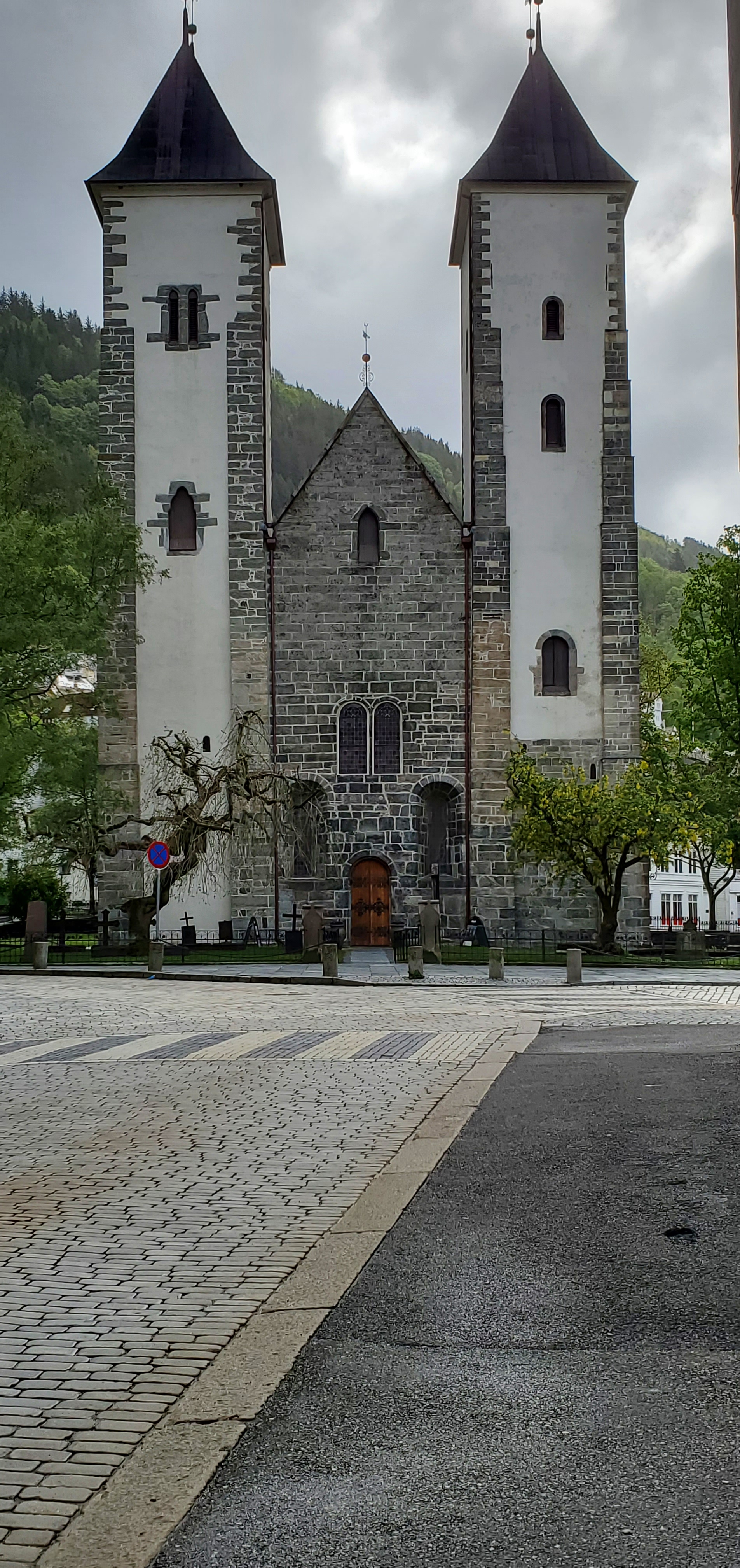
There are 3 big churches in town. We went inside St. Nicolai. It was built in the 15th century and was a church dedicated to the sailors. There were boats hanging in the main area.

There were several squares around the town. The main one was near the town hall with many historic building surrounding it. On the day we were there, there was a group of 2nd grade children performing. They sang and played simple instruments. We even saw 2 couples going into the town registry to get married.

It was an interesting town and we learned a lot from our guide, Gertrude, who actually lives in Luneburg.

We sailed late afternoon, on our way to Scotland.

Categories: Uncategorized | Leave a comment

Hamburg, Germany – day 1

Today was a washout, literally. We woke up to a drizzle, but by the time we were leaving the ship for our tour it was pouring. Hamburg is in the northern part of Germany and is the second largest city in Germany with a population of approximately 1.7 million. It lies at the intersection of 3 rivers and has many canals as well. The city has 2,500 bridges with New York City being the only city with more bridges.

The city has a vast transportation system – buses, tramcars, underground trains and trains. There are 5 major train stations in the city. The traditional buildings are made of light colored sandstone with copper roofs. Most of the buildings from the 1800s to late 1900s are made of red brick. There was a large amount of building cranes with lots of building going on. These new buildings are modern big city looking.

The old warehouse area built from 1880 to 1920 is now part of a UNESCO area. There is a big area near this being developed as a modern new city. Hamburg is a cultural city with a new opera house, of very striking design, Elbphilharmonie, fondly called Elfie by the locals.

We drove through the city seeing the usual town hall, churches and other famous landmarks. We passed the red-light district where the Beatles got their start playing in bars in the area.

We then boarded a steam powered boat for a ride on Alster Lake. This is a huge lake system, 2 big lakes in the center of town. It was still raining so it was hard to see much. We passed through and by, beautiful parks and homes. This is obviously the upscale part of town. The American embassy is on one of the lakes. The city has been named a European Green Capital for all the beautiful trees and parks.

It finally stopped raining when we got back to the ship, so we were able to eat lunch on the deck, but still had to wear our warm jackets because it was chilly.

We overnighted in Hamburg.

Categories: Uncategorized | 1 Comment

A day at sea

We finished the first part of our journey with a day at sea sailing from Stavanger to Hamburg, Germany. The seas were perfectly calm and we even had some sunshine.

We exercised and found some bridge players and spent part of the afternoon playing.

Some final thoughts on Norway. It is an exceedingly beautiful country. The weather was fairly constant – cold, cloudy and misty rain. As the Norwegians say, there is no bad weather just bad clothes. We had bad clothes, not being well prepared for the degree of coldness we encountered. We however were able to layer up and mostly be warm. One pair of gloves was purchased by Bette.

The Norwegian guides, who were mostly not from Norway, spoke so proudly of the country. We did not have many chances to meet people but from what we were told they are happy and content. We never saw any homelessness and the streets were clean with very little graffiti. The Norwegians are very outdoor oriented going out to nature every chance they get. Most have cabins (very bare minimum shelters) outside of their towns and spend their weekends with family and friends being active. Babies nap outside all year round.

It was a very interesting trip so far. More adventures to follow.

Categories: Uncategorized | 2 Comments

Stavanger, Norway

Stavanger was settled over 12,000 years ago, because of the natural deep water harbor. It is the 4th largest city in Norway with a population of 140,000. It’s name comes from the words Stav, meaning hills with oak trees and Vanger, meaning harbor. The original industry was timber, then preserving herring in the 1800s and then canning both fish and vegetables. Now it is a tourist destination and is involved in the oil and gas industries.

We did a walking tour of the town. Our first stop was at the Canning Museum. It was interesting to see the old equipment and hear how much labor was manual when this industry was first started. It eventually became mechanized, but the drying of the sardines was still a hands on job. The smokers, the men who dried the fish, were the best paid and were usually well to do. After seeing the canning museum we walked through Gamle Stavanger with all of the old homes. They were in good repair and most had beautiful gardens. We went to a cafe that was in a building built in the 1700s and is still owned by descendants of the original owners. We got to taste 4 different types of sardines.

Our tour continued on the the town’s cathedral. It will be celebrating it’s 900th birthday in 2025 and was totally covered in scaffolding since the entire building is being renovated. It was built by the king of Denmark in payment for a divorce from his then wife so he could marry a beautiful young girl from Stavanger. It seats 800, but at the time it was built the population of Stavanger was only 150.

Norway is among the top 10 fishing nations and exports 140,000,000 seafood dinners a day.

We passed the town library which is used as a center for most of the towns activities. Our guide told us that Norwegians read more books and newspapers per capita than any other country. She also said that Norwegians are prolific knitters, using the wool from the 2 million sheep that call Norway home.

In the 1970s oil was discovered off the coast and it changed Stavanger. It brought in many people from other countries and the city became more cosmopolitan. There are all kinds of restaurants serving many different cuisines. Although they are huge gas and oil producers, Norway exports almost all of it’s gas. This is because they use mostly electricity which is supplied by hydroelectric plants.

Our last stop on tour was to the former watchtower for the town. Men manned it day and night to alert the citizens of fire, since in the day, all the buildings were built of wood.

This was our second visit to Stavanger and again, we did something different and learned a great deal.

Stavanger Cathedral, photo taken from Wikipedia page
Categories: Uncategorized | 1 Comment

Eidfjord, Norway

We sailed the morning before we got to the port of Eidfjord. Eidfjord means a small place between 2 waters. The town is surrounded by mountains and each one had at least one waterfall. The scenery here was among the most spectacular we have seen.

Once again we were on great roads going through the mountains by way of tunnels. The roads were narrow, but it seemed like this was not as an inhabited area as we had been previously.

Our first stop was at the Norsk Naturcenter. We saw a film that was almost in the round, which had us flying over the Hardanger Plateau. The scenes were of spectacular beauty. The Hardanger Plateau covers over 6200 square miles. After the film we had time in the museum itself. It was a totally interactive museum. It followed the creation of Norway from 450,000 years ago. It showed how the land formed, how it became inhabited, how the ice ages came and went and then about the people and animals. The building was an event in itself.

We then rode to Flossi and stopped at the hotel there. The reason we stopped here was to see the Voringfoss waterfall. It is over 600 feet high. Not only was there this one waterfall, but about 5 others coming from other directions. It was truly amazing to see. We had a coffee break with apple pie at the hotel. The hotel was built in 1891, but no real roads were built until 1915.

We learned that fishing and tourism are the main industries in the area. They also mine slate to make roofing tiles.

Our last stop was at a huge stone dam. We were able to walk on the top of the dam. The area was snow covered and it looked like the water was partially frozen. The water from the dam goes through 2 underground tunnels to the hydroelectric plant. The dam holds over 330 million cubic meters of water.

The ride back to the ship was a continuum of beautiful mountain scenery and waterfall after waterfall. It was a true day of beauty.

The beautiful scenery continued as we sailed that evening with high mountains and waterfalls on either side of the fjord.

Categories: Uncategorized | Leave a comment

Alesund, Norway

Although this was our 3rd visit to Alesund we ended up doing something different. Alesund is a quaint town. The buildings are colorful and built in the Liberty style. The city was mostly destroyed by a fire on January 23, 1904. When the city was rebuilt the buildings had ornate fronts with lots of colorful decorations as well as many windows.

Alesund is built on 7 islands and there are many more islands in the surrounding area. Most of the islands are hilly. About 48,000 people live in Alesund. The main source of income for the area has been fishing for cod and herring and ship yards. During WW II, Alesund served as a major port for those trying to escape. Many houses have grass roofs, which serves as insulation both during winter and summer. Housing costs are around $200,000 to just under $1,000,000. 95% of the electricity comes from hydroelectric production.

Almost every house had a flag pole outside. The Norwegians fly a small triangular flag to signify a personal event, birthday, new baby, wedding, etc. They fly a rectangular flag for holidays. It also seemed that almost every house had a trampoline in the back or side yard.

My tour took me to the outer islands. First stop was the in town mountain, Aksla. It is a good viewing point to see the whole town below as well as the many islands that surround the city. It was very cold and windy there, but my guide was able to show me the mountain that Bob was hiking. It looked like it was covered in a thick fog.

We then traveled through 2 of their 4 sea tunnels, of which they are very proud. They were long, over 3.5 kilometers each. They no longer charge a fee to use them, since they have been paid off. Our first stop was on Godoy, on Alnes Island. We had a coffee and pancake stop and then got to see and climb the lighthouse.

Our next stop was on Giske Island at the local church. It is over 900 years old. When the church was being restored around 1756, a young man by the name of Jacob carved the altar piece. He was just 22 years old and because of his talents was given the honor. He subsequently carved all of the wooden objects in the church and also did the painting of them. The church is still in use today.

Bob hiked Sugar Lump Mountain. He said it was one of the more difficult hikes he had done. It was cold and windy. The trail was mostly rocky and very steep. In addition it was misty/rainy which made the trail slippery. He came back cold and muddy. I got to do a load of laundry to both clean his clothes and get his jackets dried out.

Last nights sailing was like being on a roller coaster. The winds were high and the seas were over 10 feet. We both ended up wearing our “sea bands” which helped a lot. Seasickness adverted.

Categories: Uncategorized | Leave a comment

Olden, Norway

Olden is a village of about 700 people at the end of the Nordfjord, the sixth largest fjord in Norway. The area we were in was surrounded by tall mountains, some still covered in snow.

The “town” is Loen and it is very small as well. It has the largest meat packing plant in Norway and almost everyone is employed by it. They not only deal with cows, but also goats, sheep and horse. The roads we drove on were very narrow, with cars that had to pull over so our bus could pass by. There are a lot of “hobby farms”. These are small farms, that basically grow food for themselves. We learned that during the winter the roads often are impassable so the children that live on these farms can’t get to town for school. It appears that almost every small village/town has their own school up until high school.

We drove along Loen Lake which is about 10 kilometers long. It has an average depth of 100 meters (you will have to do the math on these numbers). The water comes from the glacier and is quite cold. There was a small white sand beach.

We were told about 2 tragedies in the area. In 1905 and then in 1936, there were huge rock slides from Mount Ramnefjellet. These rock slides caused waves of almost 72 meters and washed away all the homes and the people living in them. 61 were killed in 1905 and 74 in 1936. Now the people who live in the valley have built higher up the hillsides.

We were able to do a short walk to see the Kjenndal Glacier part of one of the largest inland glaciers in Europe. We stopped along the river to see a waterfall and to see if we could see any salmon going upstream to spawn.

All along the road we traveled were beautiful views of mountains and waterfall after waterfall. The area has summer skiing from May to September with 2 fairly large hotels in the town of Loen.

We next stopped at a small cafe for traditional Norwegian waffles – they look like waffles but are long and thin and you put strawberry jam and cream on them. They were very good.

We next had a 45 minute motored boat ride on the lake. It was still pretty cold even at 1 PM so Bette opted to ride inside. Bob was on the top deck until the wind picked up and the rain started.

This was a tender port, and we had to wait while they repositioned the ship. No explanation why, but maybe because the water was choppy from the wind and rain. It ended up clearing about the time we sailed away.

Categories: Uncategorized | Leave a comment

Bergen, Norway

Today we are in Bergen. Thinking back it is our 4 visit here and the second this year. This time we were on a walking tour, no bus to ride. Made us happy.

We started at the fort and saw the fortress first. Bergen was the original capital of Norway in the 1200s. Trondheim was the religious center, but Bergen was the political center.

The Bergenhus Fortress has 2 main towers, Holmen and Rosenkrantz. It is the oldest fortress in Norway. It was partially destroyed during WW II, when a ship blew up near it in the harbor. It has been rebuilt to the original specifications.

We next went to St. Mary’s Church. It was built in 1240 and has never been destroyed or rebuilt. Since it is a civil holiday today, it was closed.

We next started our tour of the Bryggen, the merchant buildings. It was started as warehouses by the Germans during the Hanseatic Era. It is several blocks of wooden buildings which today have been restored to their original look. They are mostly colored in red and yellow. Today there are small stores selling souvenirs, jewelry and other goods. Many spaces also house restaurants. It is a UNESCO world heritage site and those that use the spaces have many rules to follow. We saw the Schotstuene which was the only building in the complex that could have a fire and so all hot meals were served there. It was also where you could get a warm bath and we heard it was also part of the red light district.

Our walk continued to the Magic Ice Bar, where we donned parkas and gloves and had a drink in an ice glass. The walls were covered with ice decorations recreating some of the famous Norwegian art by its famous artists.

We finished at the fish market area. We carried umbrellas, but it never rained. It was pretty cold, low 40s and very windy, but it was a fun day.

Holmen Tower – Bergenhus Fortress
Rosenkrantz Tower – Bergenhus Fortress
St. Mary’s Church
Entry door to St. Mary’s Church
Inside the ice bar – Vigeland reproduction
Categories: Uncategorized | Leave a comment

Kristiansand, Norway

We started out with sun. The town of Kristiansand is the fifth largest in population in Norway with 114,000 inhabitants. Like the other places we have been so far, the original city was built of wooden houses, but after many fires they now are mostly brick or stone or other hard materials.

Kristiansand is named for the first official king of Norway and he had the town built in this harbor around 1641. People have been living in this area since the Ice Age and they have found remains that are 9000 years old.

Kristiansand is one of Norway’s southern most cities. On the outskirts there are many summer cottages. There are many coves and inlets where these houses are built. The Norwegians are a very outdoor oriented people and do sports and activities all year outside. This area is called the Norwegian Riviera. Every little cove and inlet was full of boats of all kinds. It was an interesting stop.

Our tour took us to the outer area of Kristiansand, called Sogne. We walked along the old main street which was barely a car wide. All the houses were painted white which in olden times indicated wealth. They all had water views and our guide told us that they pass from one family member to another. The houses, because of the location right on a small bay, are worth about $1,000,000.

We then walked down to the waters edge and saw some interesting sculptures.

Our guide had indicated that she had lived in Boston at some time so we stopped to talk to her. We asked if she had been anywhere else in the US and she said yes, she had an aunt in Florida who she visited often. We said that we were from Florida and asked her where her aunt lived and she said…Fort Myers! Her aunt lives about 15 minutes from us on Corkscrew Road.

We stopped by to see a church from 1536. It had a rune stone in a courtyard across the road from the actual church building. We wandered through the church graveyard.

Then we went to another open air museum. At this one we were actually able to go into one of the very old buildings and see how the people lived in the 1600’s. They also had some more modern homes from the 1800’s with furniture depicting their lives.

Our day ended back in the ship watching the rain.

Categories: Uncategorized | 2 Comments

Oslo, Norway – day 1

We sailed all morning up the Oslo Fjord, passing many islands along the way. Oslo is the capital of Norway. It is a city with lots of new buildings along side many old ones. Although our day here is a Monday, there were lots of people outside enjoying the nice weather (60 degrees).

We learned some history of the city, which was the capital and then not. The hierarchy goes back many centuries and at one time this part of the world was part of Norway, Sweden or Denmark. It currently is a royal country, with a king. The population of Norway is around 5.5 million with around 1 million in the Oslo area. Many people commute to the city by ferry from the island and surrounding area. It is the largest, in area, capital in the world covering 175 square miles.

Norway has half of Europe’s coastline. The king and queen live in a palace in the center of the city, but the grounds are open to all to enjoy.

Our tour for the day was called Viking Explorers. It included visits to an exhibit about the Vikings of old and to the Fram Museum, with the ship Fram that Roald Amundsen sailed in the Arctic and Antarctic. We were even able to get on the ship and walk around.

We then went to the Kon-Tiki museum. They had the actual raft that Thor Heyerdahl used to travel from Peru to Polynesia. They also had his papyrus boat, Ra II, that he used to sail from Morocco to Barbados. For a man who never learned to swim, most of his adventures were at sea.

Our final stop was Viking Planet, which had interactive displays about the Vikings and their culture. They were not the barbarians that films depict them to be. The Viking Boat museum is closed for renovations but this stop had a 3-D site and we were able to see boats and artifacts from about 800.

We had a quick stop at the Town Hall where the Nobel Peace prize is awarded. All other Nobel prizes are awarded in Sweden.

Poor internet service, no photos today.

Categories: Uncategorized | Leave a comment

Blog at WordPress.com.